Location data is everywhere: Nearly every database includes addresses, placenames, or other positional information. Thanks to advances in AI techniques for geospatial data, such as deep learning and generative models, it is now easier than ever to extract insights from location-based data. These new capabilities offer opportunities across all industries, from optimizing city layouts in urban planning, to targeted marketing, to monitoring environmental changes in agriculture and forestry.
One major shift in this domain is the rise of agentic AI—autonomous systems that can reason, plan, and execute tasks with minimal human intervention. These AI agents are beginning to automate the ingestion, processing, and analysis of location-based data, streamlining traditionally complex workflows, and making powerful geospatial analyses accessible to both experts and non-specialists, often through natural language interfaces to cartographic maps.
However, the use of these AI techniques on high-resolution imagery, sensor feeds, and other location-based data sources is creating new challenges for existing tools and workflows. To truly harness the potential of AI—including agentic solutions—organizations need an infrastructure that is up to the task.
This is where cloud-native platforms make a difference. By providing on-demand scalability, agility, and cost efficiency, cloud-native infrastructure allows organizations to effortlessly scale AI workloads. They enable a higher degree of automation and offer standard interfaces to easily integrate with other services. This means they can keep pace with growing data volumes and evolving business requirements—without the need for complex architectural changes.
Modernizing Geospatial Platforms in the Cloud Era
Recently, CARTO launched their cloud-native platform for geospatial analytics and agentic GIS on the Oracle Autonomous AI Database. CARTO, a global Oracle Partner Network (OPN) partner, has been recognized since 2012 for making location intelligence widely accessible by offering user-friendly tools for both technical and non-technical audiences. The CARTO platform is trusted by large enterprises across diverse industries for applications such as optimizing network planning, assessing risk, and identifying growth opportunities.
The solution includes a suite of low code and no-code tools that lowers the barrier to sophisticated location analytics. CARTO Workflows provides a drag-and-drop interface that allows users to design, automate, and share spatial analysis pipelines without writing any code. The Builder tool offers an interactive environment for creating custom map visualizations and dashboards, empowering users to perform advanced geospatial analyses without the need for deep GIS expertise.
Beyond usability, the CARTO platform provides more than 100 advanced spatial analytics functions and efficient visualization capabilities for large datasets. Organizations can also accelerate solution development using a comprehensive library of prebuilt, domain-specific processing workflows—supporting diverse use cases such as cell tower site selection for telecommunications and flood risk assessment for insurance.
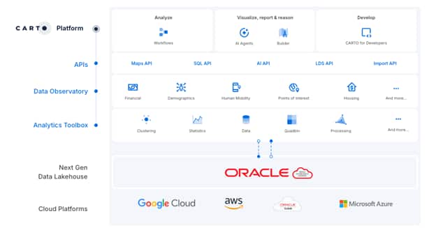
Support for Agentic AI is the latest innovation within the platform. With Agentic GIS, organizations can encapsulate GIS expertise within intelligent AI agents and reusable automated workflows. These agents can autonomously manage spatial data, perform complex analyses, and deliver insights in real time, reducing reliance on scarce GIS specialists. By embedding these intelligent agents throughout the business, organizations foster greater collaboration between departments—enabling data engineers, analysts, and business users to streamline operations and accelerate decision-making.
Finally, organizations benefit from CARTO’s curated marketplace of more than 12,000 third-party spatial datasets—including socio-demographic data, human mobility data, and administrative boundaries—further accelerating insight generation and application development.
Integrating CARTO with the Oracle Cloud Ecosystem
At the core of CARTO’s architecture is its deep integration with the spatial features of Oracle Autonomous AI Database. Embracing a true cloud-native model, CARTO compiles its geospatial processing and analytics logic into optimized SQL executed directly in the database tier. This approach enables data-intensive spatial operations to perform where the data resides—eliminating the need to move large datasets to a client or to replicate data to an external server.
CARTO and Oracle Autonomous AI Database run on all major clouds: OCI, AWS, Azure, and Google Cloud. This allows organizations to choose their preferred hyperscaler based on where data and workloads reside. That said, for organizations running workloads on Oracle Autonomous AI Database, OCI offers a particularly attractive deployment option, combining the seamless integration of Oracle’s cloud services, including OCI Functions and OCI GenAI Services, with competitive and predictable pricing models and enterprise-grade security and availability for geospatial data.
Through open standards such as the Model Context Protocol (MCP), CARTO’s Agentic GIS workflows integrate seamlessly with Oracle’s suite of AI tools, supporting more dynamic, scalable, and intelligent geospatial solutions. This positions organizations to take full advantage of agentic, collaborative AI tools for spatial analysis and automation across the enterprise.
Finally, CARTO’s flexible deployment model extends to regulated industries and sensitive use cases. Organizations can run CARTO on Oracle’s EU Sovereign Cloud to address stringent European data residency and compliance requirements, or deploy on-premises for maximum control over geospatial data and workloads.
Unlocking Value for Oracle Spatial Customers
CARTO’s flexible platform architecture is designed to maximize the value of existing Oracle investments, no matter where the data resides—on-premises, in the cloud, or in hybrid setups.
The benefits extend to all types of spatial data, including 2D and 3D geometries, georeferenced raster imagery, networks, and LIDAR point clouds. CARTO can seamlessly access geospatial information stored inside the database, within data lakes, or in external object storage—thanks to Oracle’s data integration capabilities.
For data engineers, CARTO’s support for external tables is particularly compelling. Teams can easily integrate and analyze location data from OCI Object Storage, Amazon S3, Apache Iceberg, and Parquet, allowing organizations to unlock new spatial insights from modern cloud storage formats or distributed data repositories.
By taking advantage of the standards-based approach built into Oracle Spatial, organizations benefit from interoperability between their existing tools and custom applications. This means organizations can continue working with familiar software for managing location-based data in Oracle, while expanding their analytical capabilities and workflows with the advanced features offered by the CARTO platform.
Looking Ahead: Transform Your Geospatial Future
Oracle and CARTO’s partnership empowers enterprises to modernize their geospatial landscape with AI-driven automation, comprehensive analytics, on a scalable, secure, cloud-native platform. Together, we help organizations optimize decision-making, enhance collaboration, and accelerate industry-specific solutions—all while maximizing their Oracle investment. To learn more about how Oracle and CARTO are shaping the future of enterprise geospatial analytics, read Javier de la Torre’s blog post or get in touch with the experts.
Learn More
For more details about CARTO on Oracle and on the spatial features of the Oracle AI Database be sure to check out the following online resources:
- CARTO on Oracle: https://carto.com/oracle/spatial-analytics
- AskTOM Office Hours session with CARTO: https://youtu.be/VS8lazR1zHA?si=o7Uu8HwVo1tL2Mod
- Oracle Spatial: https://www.oracle.com/goto/spatial
- Oracle Spatial Youtube Channel: http://www.youtube.com/@oraclespatialandoraclegraph